
STATE & NATION TRAVEL · news
Great Basin’s November burn plan does not confirm current Baker Creek access
By Staff Writer · Published October 29, 2026 · Updated November 13, 2026
Updated traveler guidance: the November 2 planned start has passed. This article now distinguishes the dated burn announcement from current access checks and winter campground status. Official road and alert responses retrieved for this review do not consistently establish access throughout the burn corridor; no reopening or new blanket closure is confirmed.
The October 29 notice scheduled a November 2 start. Its temporary fire restrictions and winter campground closures should not be read as a current reopening report.
Official announcement: National Park Service · October 29, 2026
Source: National Park Service October 29 Baker Creek prescribed-burn release
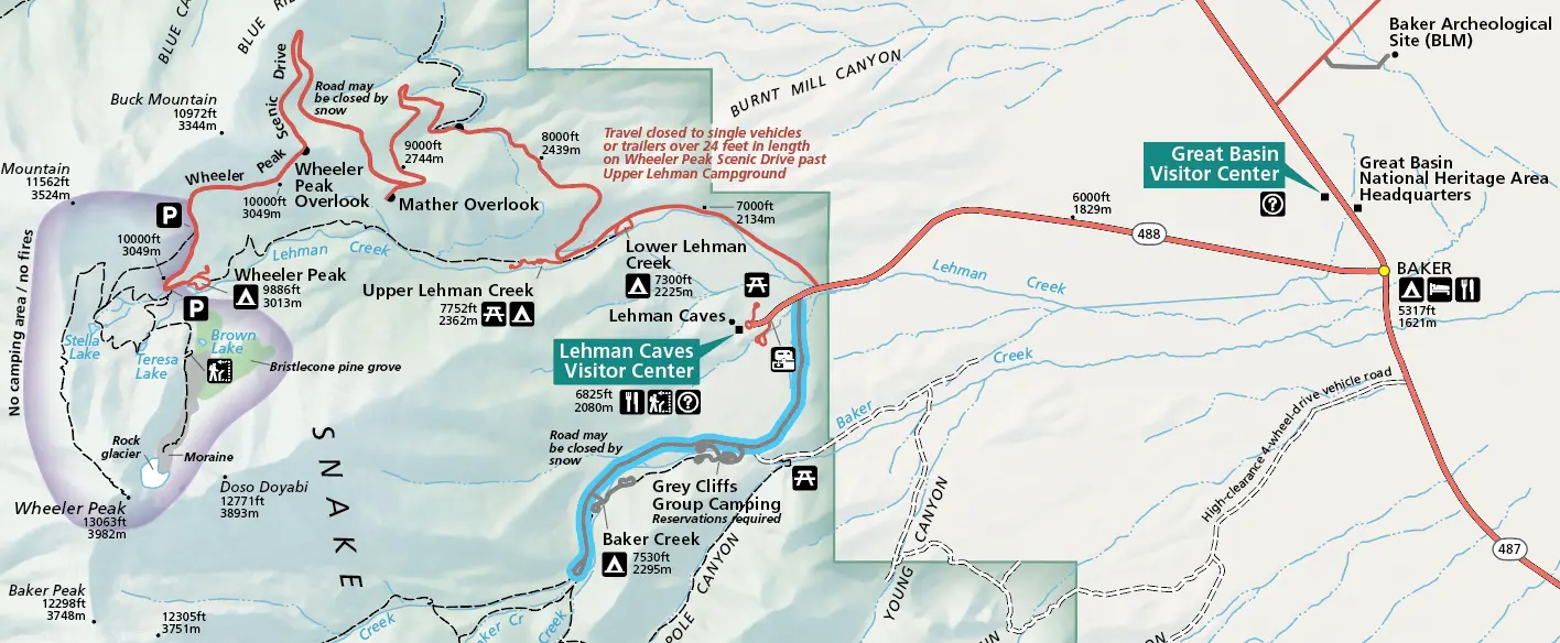
Great Basin National Park’s October 29 announcement planned an approximately 80-acre prescribed burn in the Baker Creek watershed for the week of November 2, weather and fuel conditions permitting. That planned start is now past. The release remains useful as a record of the announced restrictions, but it does not establish when the operation finished or whether every affected visitor area has reopened.
NPS said Baker Creek and Grey Cliffs campgrounds would enter their winter closure at noon Pacific time November 2. During fire operations, Baker Creek Road and Pole Canyon Road would close at their winter turnaround gates, the Baker Creek Trailhead would be inaccessible, and visitors would be excluded from the burn area. The agency tied reopening of fire-specific closures to completed operations and safe conditions, not a calendar deadline.
Current official information requires a careful distinction. The conditions page retrieved for this update lists Baker Creek Road open and describes hiking trails as open in general. The agency’s search feed also lists a November 12 alert naming closures at Pole Canyon, Timber Creek, Baker Creek and Baker Lake, but that alert was absent from the park-specific alert feed retrieved during this review. These responses do not provide a consistent basis for declaring the whole corridor open or issuing a new blanket closure report.
What this means: The old November 2 instruction is no longer a future departure deadline. Plan around the current status of the particular road, trailhead and campground you intend to use. A road listed open does not by itself settle access to every trail or to a marked fire work area.
What Travelers Need to Know
Treat the October 29 release and its November 2 schedule as dated planning information. Before entering the Baker Creek corridor, check current park notices or call 775-234-7331 to ask specifically about Baker Creek Road, Pole Canyon and your intended trailhead. Obey posted gates and fire closures; no confirmed reopening date was established in this review.
Separate winter campground operations from temporary fire restrictions. The current campground page lists Baker Creek and Grey Cliffs closed for winter. The conditions page identifies Lower Lehman Creek as the only year-round campground and requires campsite reservations through Recreation.gov. Its current reservation advice differs from the older Baker Creek trails page’s first-come description; do not rely on that older aside when planning a stay.
The park currently reports no potable water in its campgrounds. Bring your own supply and verify available services before departure. The original fire release warned that smoke could affect Baker and Snake Valley during and after operations, but that warning is not a current smoke or air-quality observation. Check current conditions separately rather than assuming the burn is still active.
About the Location
The Baker Creek corridor is part of Great Basin National Park in eastern Nevada. Congress established the park in 1986, incorporating the former Lehman Caves National Monument into a protected landscape of more than 77,000 acres. Its bristlecone pine groves, mountain terrain and caves explain why visitors may combine very different experiences within one park.
Baker Creek Road is a 3.5-mile dirt-and-gravel route reached from Highway 488 inside the park. The Pole Canyon trailhead lies about 1.5 miles along it, while the main Baker Creek trailhead is at the road’s end. That layout makes a restriction at a winter gate consequential for a hiking itinerary, even when other park facilities are operating.
Official sources
- National Park Service October 29 Baker Creek prescribed-burn release
- National Park Service Great Basin current conditions
- National Park Service Baker Creek trails and access
- National Park Service Great Basin campgrounds
- National Park Service Great Basin management and park history
- NPS November 12 full Baker Creek alert in official search feed
- NPS park-specific alert feed checked alongside conditions