
STATE & NATION TRAVEL · news
Rocky Mountain readies 437-acre prescribed burn near Beaver Meadows
By Staff Writer · Published October 26, 2026
Ignitions could begin in late October when conditions allow, bringing smoke, escorted traffic and possible temporary closures to U.S. Highway 36 and Bear Lake Road through the winter burn window.
Official announcement: National Park Service · October 26, 2026
Source: NPS October 26 prescribed-fire readiness notice and supplied map
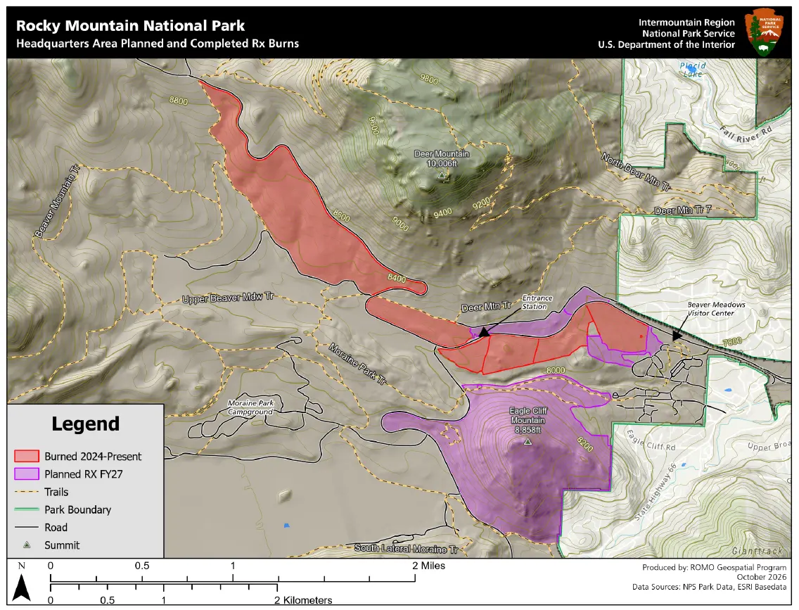
Rocky Mountain National Park is preparing to use prescribed fire on as many as 437 acres east of the Continental Divide, with ignitions possible from late October through the winter whenever weather, fuels, staffing and air-quality conditions meet the operation's limits. The work covers the Eagle Cliff Unit and parts of the Headquarters Unit between Beaver Meadows Visitor Center and Bear Lake Road, including land south of High Drive.
The National Park Service and U.S. Wildland Fire Service plan to spread burning across several days to limit daily smoke. Crews intend to remove grasses, light fuels and understory that could carry a future wildfire toward nearby communities or park facilities. NPS points to earlier fuel treatments that helped firefighters defend the Estes Park side of the park during the 2012 Fern Lake Fire and the 2020 East Troublesome Fire.
Visitors may encounter active traffic management on U.S. Highway 36 and Bear Lake Road beside the burn area. Fire personnel may escort vehicles through an operating zone, prevent roadside stopping or impose a temporary closure. The release does not publish an ignition day, daily work hours or a closure schedule, so a normal drive one day does not guarantee the same access later in the burn window.
Smoke may remain after ignition as fuels smolder for three to 10 days, and NPS expects some of it to move east of the park. The announcement is a readiness notice rather than confirmation that burning has started; managers will continue to evaluate safety, weather, air quality, personnel and environmental rules before proceeding.
What Travelers Need to Know
Check the park's current fire-information and road pages immediately before entering from Estes Park or driving toward Bear Lake. The October 26 release gives a seasonal burn window, not a fixed ignition date, and temporary closures or escorted traffic may be announced with shorter notice.
Do not stop along U.S. Highway 36 or Bear Lake Road inside an active burn area, cross barriers or leave a vehicle during an escort. Follow firefighter and ranger directions even if a map or earlier update shows the road open.
Allow extra driving time and carry an alternate plan for the day. If traffic controls block the intended route, use only an officially open entrance or destination; do not detour onto restricted park roads or private roads around Estes Park.
Travelers sensitive to smoke should review the official air-quality and smoke guidance linked by NPS and reconsider strenuous outdoor activity when conditions are poor. Visible smoke does not by itself identify a wildfire, but any unattended fire or immediate threat should be reported to 911.
About the Location
Rocky Mountain National Park protects 265,807 acres in northern Colorado, spanning montane valleys, subalpine forest and alpine tundra on both sides of the Continental Divide. The park was created in 1915 after naturalist Enos Mills and regional conservation groups pressed for federal protection, and its roads and visitor centers later made the high country accessible to generations of travelers.
Beaver Meadows is the park's principal eastern gateway from Estes Park. The visitor center and the junctions serving U.S. Highway 36, Trail Ridge Road and Bear Lake Road concentrate arriving traffic near the proposed burn units. That geography gives the fuel project a dual significance: it is designed to create a more defensible landscape near developed facilities, but operations can also affect two of the park's most heavily used travel corridors.