The National Park Service is proposing updates to special regulations for Big Cypress National Preserve that would make way for implementation of the 2010 Addition Lands General Management Plan (GMP). The National Park Service will carefully review public comments before making any final decisions.
Size: 30,225 acres as of 2/27/2026, 6:15pm Containment: 0% Cause: Unknown, Under Investigation Location: 25 miles east of Naples, Florida; south of I-75, east of SR-29. Start Date: February 22, 2026 Resources: 14 engines, 3 water tenders, 4 helicopters, 3 single engine airtankers (SEATs). Total Personnel: 154
Size: 25,780 acres Location: 25 miles east of Naples, Florida; south of I-75, east of SR-29. Start Date: February 22, 2026 Cause: Unknown, Under Investigation Containment: 0% Resources: 14 engines, 3 helicopters, 3 Single Engine Airtankers (SEATs). Total Personnel: 120
OCHOPEE, FL – Big Cypress National Preserve has issued an amendment to the area closure issued on February 23. The amended closure is in effect immediately and includes all areas and trails within the closure perimeter, as well as perimeter roads within the preserve. During the closure, all recreational use including off-road vehicles, hiking, camping, hunting and commercial activities are prohibited in the designated areas. This amended closure re-opens Burns Lake Campground for reservations and day use.
OCHOPEE, Fla. – The National Fire remains active as persistent drought conditions and widespread frost-killed vegetation continue to create an unusually heavy and highly receptive fuel bed. Ground crews continue to conduct defensive firing operations along the southern portion of the fire to help establish a perimeter. Aviation resources supported suppression efforts by conducting aerial firing operations to eliminate interior pockets of unburned fuel.
OCHOPEE, Fla. – Ongoing wildfire activity within Big Cypress National Preserve continues to expand due to persistent drought conditions and recent frost damage that has created an unusually heavy and highly receptive fuel bed. Dry vegetation combined with accumulated frost-killed fuels is contributing to active fire behavior across the preserve.
OCHOPEE, Fla. – Late on February 22, two fires were discovered within Big Cypress National Preserve. Local ground and aviation crews are actively engaged in fire suppression activities, and additional resources have been requested.
Map of FY2026 Proposed Prescribed Fire Treatment Areas · NPS Maps · Official image source · No claim to original U.S. Government works.
National Park Service South Florida Fire & Aviation will conduct a series of prescribed fire operations across Big Cypress National Preserve over the coming months, as weather conditions and other parameters permit. The planned treatment areas cover approximately 81,002 acres in 4 separate burn treatment units, strategically placed throughout the preserve as part of a multi-year fuels treatment plan.
Mullet Rx Public Map · NPS Map · Official image source · No claim to original U.S. Government works.
Big Cypress National Preserve has issued a temporary trail closure to promote visitor safety during prescribed fire activity, beginning Monday, June 9, 2025. Closure includes all portions of the Florida Trail (see below), areas and trails within the treatment perimeter, trails on the perimeter of the unit will remain open for use. During the closure all recreational use including off-road vehicles, hiking, camping, hunting and commercial activities are prohibited in the designated areas.
4 Phase Boundary Rx burn plan map · NPS Map · Official image source · No claim to original U.S. Government works.
OCHOPEE, FL –Big Cypress National Preserve has re-issued a temporary trail closure to promote visitor safety during prescribed fire activity beginning Tuesday, February 11, 2025. The new closure includes all areas and trails within the treatment perimeter however, due to changes in weather and environmental conditions, the previously planned Boundary Prescribed Fire Phase 1 treatment perimeter has been amended. During the closure, all recreational use including off-road vehicles, airboats, hiking, camping, hunting and commercial activities are prohibited in the designated areas.
Boundary Rx Prescribed Fire Map · NPS Map · Official image source · No claim to original U.S. Government works.
OCHOPEE, FL – Big Cypress National Preserve has issued a temporary trail closure to promote visitor safety during prescribed fire activity beginning Monday, February 10, 2025. Closure includes all areas and trails within the treatment perimeter, as well as potential periodic closures along Loop Rd. During the closure, all recreational use including off-road vehicles, airboats, hiking, camping, hunting and commercial activities are prohibited in the designated areas.
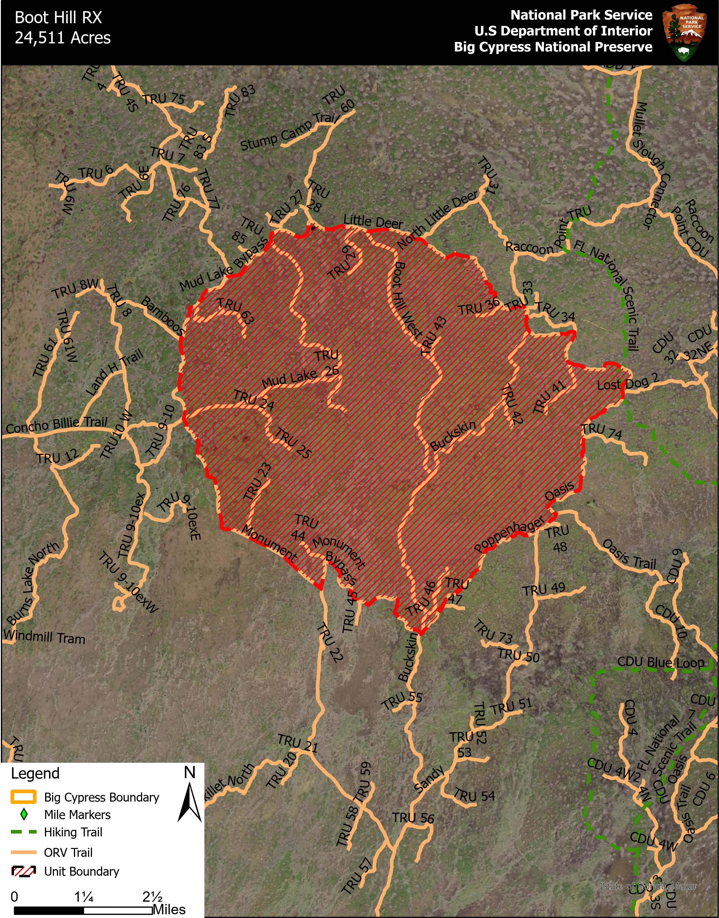
FY25 Boot Hill Rx Public Closure Map · NPS Map · Official image source · No claim to original U.S. Government works.
OCHOPEE, FL – Big Cypress National Preserve has issued a temporary trail closure to promote visitor safety during prescribed fire activity beginning Friday, January 24, 2025. Closure includes all areas and trails within the treatment perimeter, trails on the perimeter of the unit will remain open for use. During the closure, all recreational use including off-road vehicles, hiking, camping, hunting and commercial activities are prohibited in the designated areas. Unlike the closure earlier this month, during this closure, all parts of the Florida National Scenic Trail will remain open.
An aerial view of prescribed fire · NPS photo by Michael Gue · Official image source · No claim to original U.S. Government works.
MIAMI, Fla. – The National Park Service (NPS) in conjunction with the Miccosukee Tribe of Indians of Florida and the Bureau of Indian Affairs will be conducting a joint prescribed fire operation scheduled to begin in late January and continue through February. The 151,434-acre Boundary Prescribed Fire Project—located south of US Highway 41 between mile markers 36 and 44, including the Miccosukee Reserved Area—removes jurisdictional boundaries to complete prescribed burns with the assistance of federal, Tribal, state and local resources. The project aims to reduce hazardous fuel accumulations, create a critical fire break on the south side of the Miccosukee Reserved area to protect the Tribal Community from wildfire, enhance landscape resiliency, aid in ecosystem restoration, protect cultural values and improve firefighter and public safety.
FY25 Boot Hill Rx Public Closure Map · NPS Map · Official image source · No claim to original U.S. Government works.
OCHOPEE, FL – Big Cypress National Preserve has issued a temporary trail closure to promote visitor safety during prescribed fire activity beginning Tuesday, January 14, 2025.
Temporary Closures for Boot Hill Rx · NPS Maps · Official image source · No claim to original U.S. Government works.
OCHOPEE, FL – Big Cypress National Preserve has issued a temporary trail closure to promote visitor safety during prescribed fire activity beginning Wednesday, January 8, 2025. Closure includes all areas and trails within the treatment perimeter, trails on the perimeter of the unit will remain open for use. During the closure all recreational use including off-road vehicles, hiking, camping, hunting and commercial activities are prohibited in the designated areas.
NPS Map of 2025 Proposed Prescribed Fire Treatments · NPS Maps · Official image source · No claim to original U.S. Government works.
OCHOPEE, FL – National Park Service South Florida Fire & Aviation will conduct a series of prescribed fire operations across Big Cypress National Preserve over the coming months, as weather conditions and other parameters permit. The planned treatment areas cover approximately 115,639 acres in 3 separate burn units, strategically placed throughout the preserve as part of a multi-year fuels treatment plan.
Big Cypress National Preserve today released the final Backcountry Access Plan/ Wilderness Study/ Environmental Impact Statement (Plan/EIS) after carefully considering all public comments on managing the preserve’s backcountry access and use.
Two wildland firefighters work to put out flames on Kirby Storter Boardwalk · NPS Image · Official image source · No claim to original U.S. Government works.
On October 14th, fire was reported at Kirby Storter Boardwalk. Firefighters quickly responded to the incident, but the boardwalk will be closed until further notice.
Following the passing of Hurricane Helene, visitors to the South Florida National Parks and Preserve should continue to exercise caution with the potential for unidentified hazards on land and in park waters. Marine waters continue to be open in all locations, but parks are still assessing missing or damaged aids to navigation. Closures or special conditions are available on each park’s website under Alerts.
Park passes, including: America the Beautiful, Veteran, Lifetime, etc., are UNAVAILABLE for purchase/pickup within Big Cypress. Shark Valley Visitor Center (Everglades) is the closest location to Big Cypress for purchase.
Interceptor Prescribed Fire Closure Area · NPS Map · Official image source · No claim to original U.S. Government works.
Big Cypress National Preserve has issued a temporary trail closure to promote visitor safety during prescribed fire activity beginning Sunday, April 21, 2024.
Turner River Closure Area · NPS Map · Official image source · No claim to original U.S. Government works.
OCHOPEE, FL – Big Cypress National Preserve has issued a temporary trail closure to promote visitor safety during prescribed fire activity beginning Monday, April 8th, 2024. Closure includes all areas and trails within the treatment perimeter including Turner River Canoe Launch (north of US41).
Kirby D Rx Closure Area · NPS Map · Official image source · No claim to original U.S. Government works.
OCHOPEE, FL – Big Cypress National Preserve has issued a temporary trail closure to promote visitor safety during prescribed fire activity beginning Friday, April 5th, 2024.
Interceptor Rx Closure Map · NPS Map · Official image source · No claim to original U.S. Government works.
Big Cypress National Preserve has issued a temporary trail closure to promote visitor safety during prescribed fire activity beginning Monday, March 18, 2024.
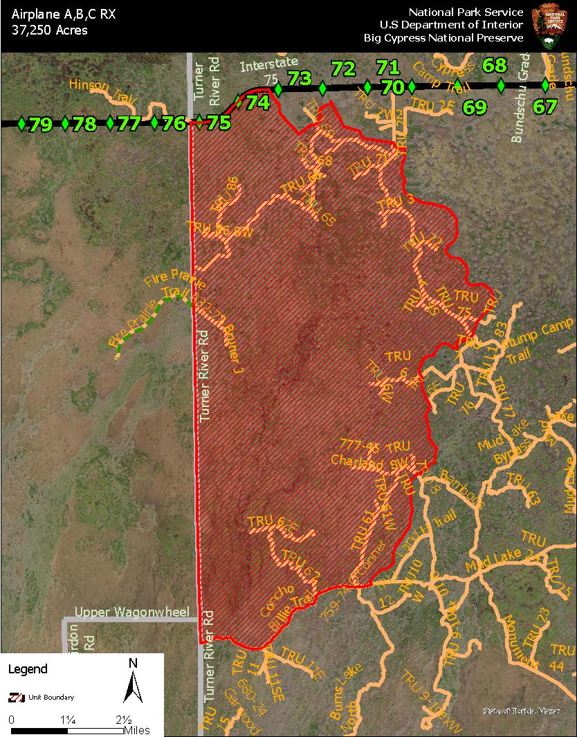
Airplane Prescribed Fire Treatment Perimeter · NPS Maps · Official image source · No claim to original U.S. Government works.
Big Cypress National Preserve has issued a temporary trail closure to promote visitor safety during prescribed fire activity beginning Monday, March 11th, 2024.
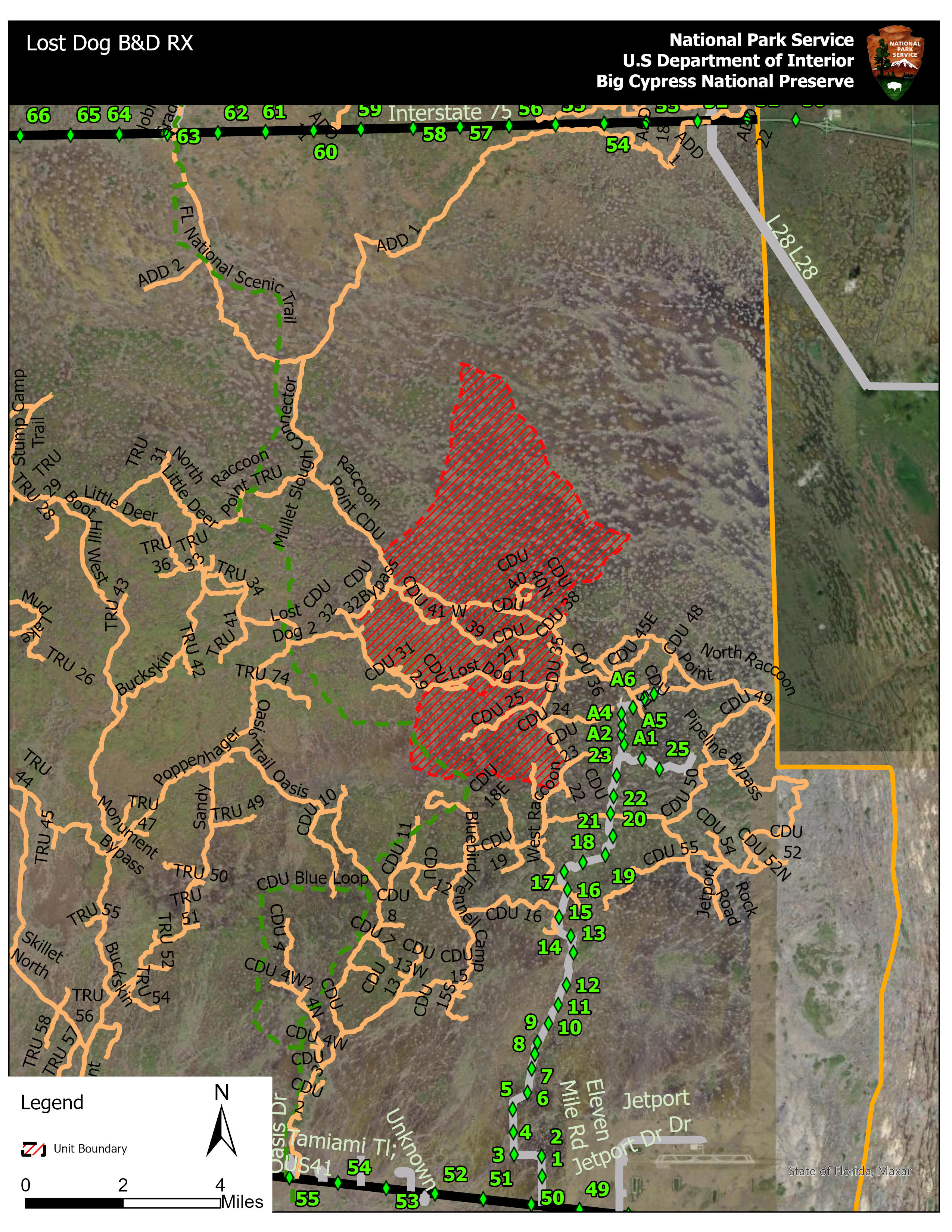
Lost Dog B & D Rx Treatment and Closure Area · NPS Maps · Official image source · No claim to original U.S. Government works.
Big Cypress National Preserve has issued a temporary trail closure to promote visitor safety during prescribed fire activity beginning Tuesday, February 27, 2024.
Kirby Rx Treatment Area · NPS Map · Official image source · No claim to original U.S. Government works.
Big Cypress National Preserve has issued a temporary trail closure to promote visitor safety during prescribed fire activity beginning Tuesday, February 20, 2024.
Lost Dog A&C RX Closure Area · NPS Image · Official image source · No claim to original U.S. Government works.
Big Cypress National Preserve has issued a temporary closure to promote visitor safety during prescribed fire activity beginning Monday, February 12th, 2024. During the closure all recreational use including off-road vehicles, hiking, camping, hunting and commercial activities are prohibited in the designated areas.
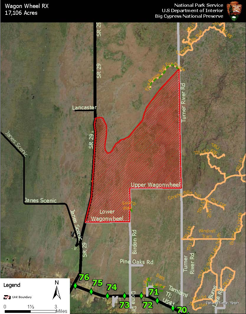
Wagon Wheel RX Public Map · NPS Image · Official image source · No claim to original U.S. Government works.
An area closure has been issued in the Wagon Wheel Unit for a RX Burn. This closure is to promote visitor safety and will remain in effect until the burn ends.
OCHOPEE, FL – South Florida Fire & Aviation will conduct a series of prescribed fire operations across Big Cypress National Preserve over the coming months, as weather conditions and other parameters permit. As prescribed fire operations are implemented, some visitor impacts are anticipated. Temporary closures are expected to ensure visitor and firefighter safety during operations.
Phase Two of the Sandy Wildfire Evacuation Plan has been initiated and residents within the areas of concern have been notified to prepare for potential evacuations. Residents with preexisting medical conditions have been encouraged to leave.
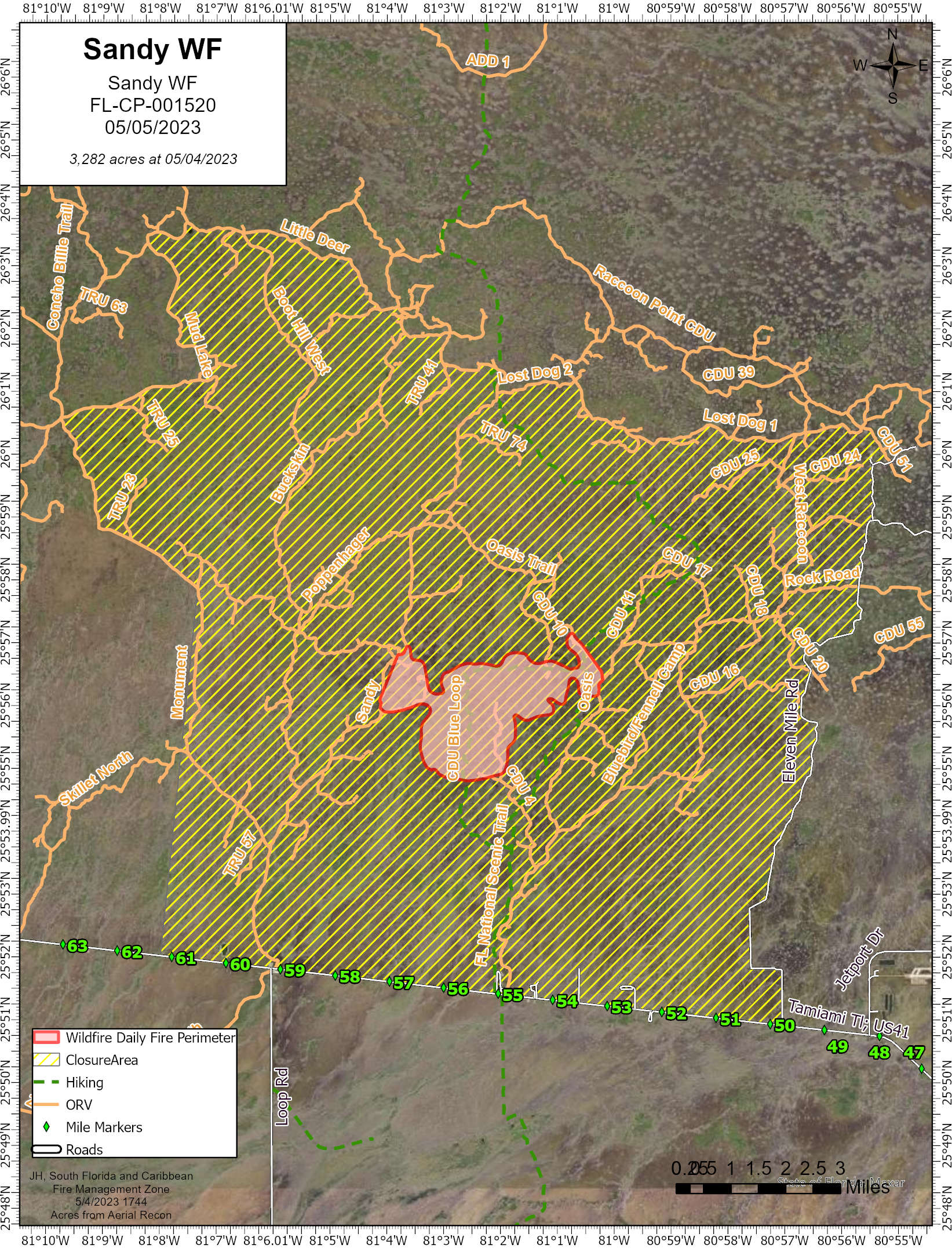
As fire managers continue to contend with dry conditions, crews are taking advantage of the favorable nighttime weather conditions to conduct suppression burn out operations on the Sandy Wildfire.
Map of Sandy Wildfire with Closure Area · NPS Map · Official image source · No claim to original U.S. Government works.
Phase One of the Sandy Wildfire Evacuation Plan has been initiated and residents within the areas of concern have been notified of potential fire impacts in the coming days. Residents in the impending evacuation zone have been advised to prepare their home and themselves for potential evacuations.
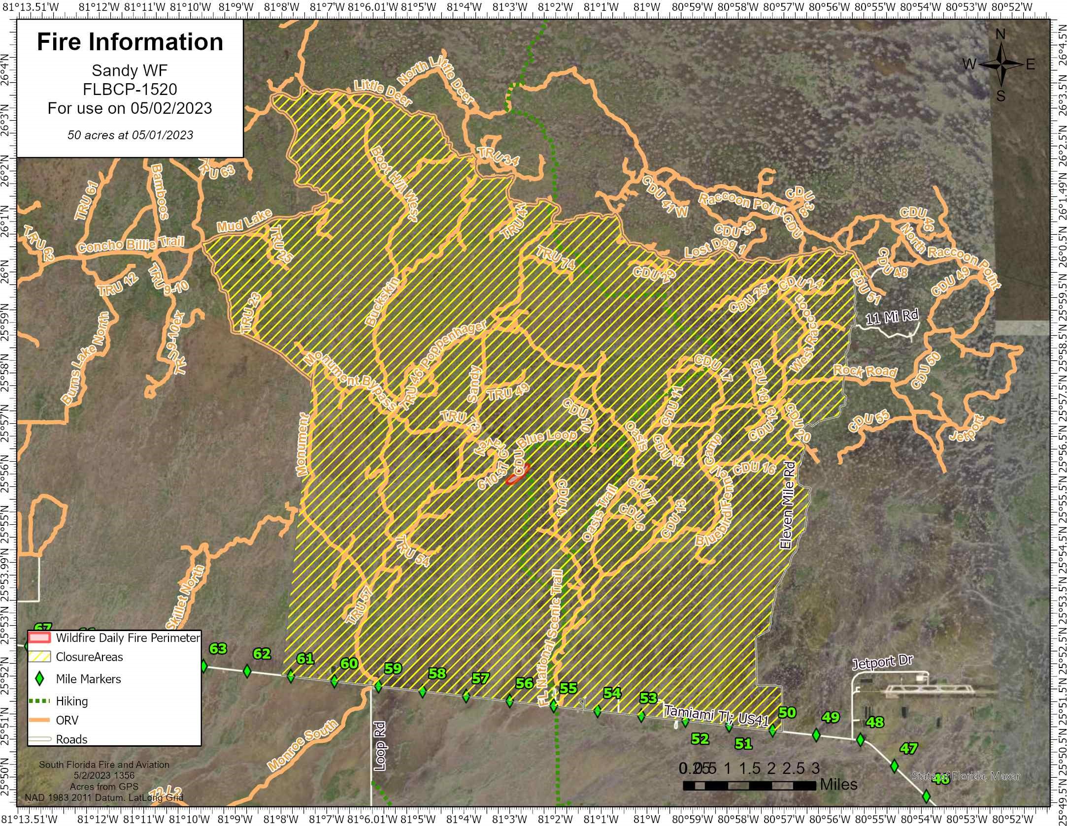
Sandy Wildfire Map with Closure Area · NPS Map · Official image source · No claim to original U.S. Government works.
OCHOPEE, FL – Yesterday, May 1st, at approximately 3:30 PM, a wildfire was discovered in Big Cypress National Preserve, located just west of the Blue Loop portion of Florida Trail. The Sandy Wildfire is currently estimated to be about 50 acres, burning in a mixture of grass, brush and pine. South Florida Fire & Aviation resources are on scene, and additional resources have been ordered.
Fire behavior on the Cypress Camp Trail Fire in Big Cypress National Preserve continues to decrease due to suppression efforts and high humidity. Due to the decrease in complexity, beginning tomorrow the fire will be managed by a local Type 4 Incident Management Team.
Fire behavior on the Cypress Camp Trail Fire in Big Cypress National Preserve has decreased significantly today with precipitation over the fire area. Creeping and smoldering continues to be observed in the prairies and pines. Current mapping puts the fire at 9,749 acres and containment has increased to 67%.
Fire crews made significant progress today on the Cypress Camp Trail Fire with containment rising to 40%, up 30% from yesterday. The fire is currently 9,722 acres.