NASA satellite tracks Isaias remnants intensifying near Iceland
By Staff Writer · Published 10/21/2026, 3:08:05 AM ET
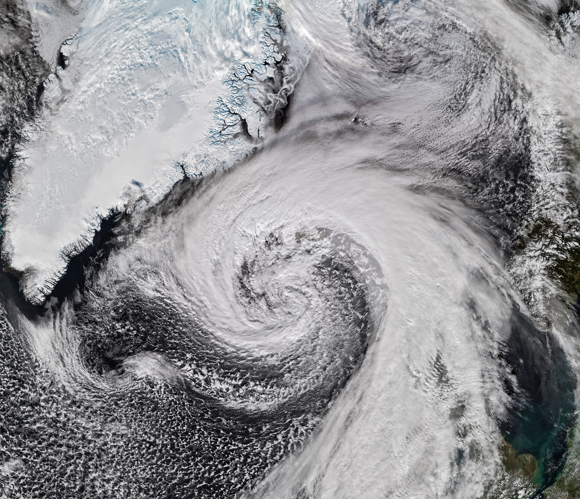
A NOAA-21 VIIRS image captured October 14 shows the extratropical cyclone formed from Hurricane Isaias’s remnants passing Iceland.
NASA Earth Observatory/Michala Garrison, using VIIRS data from NASA EOSDIS LANCE, GIBS/Worldview and JPSS · Official image source · NASA media usage guidelinesA NOAA-21 image shows the former Atlantic hurricane reorganized as a powerful extratropical cyclone, bringing damaging winds to Iceland and parts of Scotland.
NASA Earth Observatory published a NOAA-21 satellite image October 21 showing the remnants of Hurricane Isaias circulating near Iceland as a powerful extratropical cyclone. The VIIRS instrument captured the system on the afternoon of October 14, five days after the National Hurricane Center says Isaias made landfall near Destin, Florida, with maximum sustained winds of 105 mph as a Category 2 hurricane.
After moving into the North Atlantic, the remnants traveled east with the jet stream and developed the broader, asymmetrical cloud pattern typical of an extratropical low-pressure system. NASA noted that storms of this type can produce hurricane-force winds, heavy rain and wintry precipitation even after they no longer meet the definition of a tropical cyclone.
The system’s atmospheric pressure fell by more than 50 hectopascals in 24 hours during the crossing, according to reports cited by NASA. The agency described that drop as roughly twice the threshold for explosive cyclogenesis, a rapid strengthening process also called bombogenesis.
NASA said some meteorologists believed the storm may have established a new October low-pressure record for Iceland after adjusting observations for altitude. The Earth Observatory article did not present that as a finalized official record, so the claim remains qualified.
The cyclone produced a gust of 205 kilometers per hour, or 128 mph, near Eyjafjallajökull volcano in southern Iceland, while a nearby island recorded sustained winds of 150 kilometers per hour, or 93 mph, NASA reported. The agency said damaging winds also reached northern Iceland, where residents prepared for sleet and snow. Northwestern Scotland recorded gusts as high as 90 kilometers per hour, or 55 mph, and several ferry routes were canceled, according to reports summarized by NASA.
NASA Earth Observatory’s Michala Garrison created the image with VIIRS data from NASA’s near-real-time Earth-observation system and the Joint Polar Satellite System. The image documents the storm’s size and spiral structure across the North Atlantic but does not by itself establish final wind, pressure or damage assessments.
What it means
Isaias did not simply disappear after leaving the United States. Its remnants changed into a different kind of storm and intensified again over the North Atlantic, extending the system’s effects from Florida to Iceland and Scotland within days.
The satellite view provides direct evidence of the cyclone’s cloud structure, while the wind and possible pressure-record figures come from reports cited by NASA. Confirmation of any Icelandic pressure record would require a finalized meteorological assessment; NASA’s article presents the record claim as a possibility, not a settled finding.
Source
This State & Nation summary is based on NASA Earth Observatory’s original release, dated 2026-10-21. The reporting and statistics above are attributed to that publication.